Best Walking Trails in The Grampians
The Grampians Hiking Trails Uncovered
Did you know one of the highlights of visiting The Grampians is exploring the region’s amazing hiking trails? Located 3 hours’ drive west of Melbourne. The Gariwerd, as the area is known in indigenous culture. Gariwerd has been an important cultural site to local Aboriginal nations for at least 900 generations.
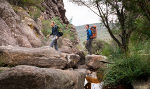
For modern-day visitors, the park offers many walking and hiking trails that pass through spectacular waterfalls, forests, peaks and lookouts. When hiking outdoors there is always the chance to see lots of local wildlife. The Grampians are home to emus, kangaroos and wallabies and more than 200 bird species.
When it comes to native flora, the Grampians is home to 20 species of plants not found anywhere else in the world. From sandstone cliff climbs to gentle creek-side circuits, the Best’s team members all have a favourite trail. Here, they share the best of the Best’s with you.
We recommend hikers to grab a detailed map before setting out on any hikes in The Grampians. Tracks range from easy, flat creek-side walks to demanding scrambling on high peaks. Most walking trails do not require permits or bookings. Dogs and other animals are not permitted in Grampians National Park. Make sure you come hike-ready in appropriate footwear and carry plenty of water and warm clothing during the winter months. For further details about The Grampians National Park, visit the park website.
Chatauqua Peak Loop Walk
Anthony Jones, Best’s Commercial Manager
Anthony’s family loves doing the Chatauqua Peak Loop Walk from Halls Gap Botanic Gardens, inside Grampians National Park. “It’s not too long, and has spectacular views at the end where you feel like you’re standing on top of Halls Gap,” he says. The 5.6km circuit boasts panoramic views and takes most hikers between 2-3 hours to complete. At 200m above sea level, the track is steep and is considered moderate difficulty.
As you get closer to the peak, climbing over rocks is required. So it’s not suitable for those with mobility issues or young children. The effort is rewarded at the summit with stunning views of Grampians National Park and Mount Gar Ranges. Make your way back down the same route, following signposts along the way. The walk will take you past breathtaking Clematis Falls. This waterfall is best viewed in the rainy season between May-August when the falls are running.
The Pinnacle Walk via Venus Baths
The more trying but rewarding walk departs from the aptly named Wonderland car park. This path ascends via the impressive Grand Canyon and through Venus Baths. If you need a break, Venus Baths is a little oasis to cool off on hot days. The trail’s unique Australian rock formations are so impressive, albeit on a smaller scale than its American counterpart. The walk continues through the Silent Street before rising up to The Pinnacle.
The Pinnacle Walk via Grand Canyon
Graeme Hogan, Best’s National Sales Manager
Graeme’s favourite walk is also The Pinnacle Walk from Wonderland car park. His tip is to make sure you swing left after crossing Stoney Creek and go up the gorge known as the Grand Canyon.
Boronia Peak Walk
Nicole Thomson, Wine Club Manager
Nicole loves the Boronia Peak Walk. Begin in the Tandara Road Carpark in Grampians National Park. Head across Fyans Creek footbridge and begin the picturesque, steady climb through Messmate forest and native pine. Follow along the Western slope of the Mount William range. There’s a rocky scramble at the end. When you reach the summit of Boronia Peak, spend some time with the superb views. Looking towards Lake Fyans in the east and over the Fyans Valley. Rock-climbers come to Boronia Peak to enjoy the amazing views of this region. The 6.6km return track takes approximately 2.5 hours. First-time climbers may find this track a little difficult – the grade is medium.
Fyans Creek Loop
A family-friendly side-trip in Brambuk National Park
A family friendly side trip is Fyan’s Creek Loop. This is an easy 2.2km circuit that takes about 45 minutes. The well-marked paths are suitable for all ages and lead you on a leisurely stroll. You will pass through wetlands, creek habitat and open eucalypt forests. Spot wildlife grazing in the open grassy areas, from kangaroos and emus to wild deer. Finish at the Brambuk National Park and Cultural Centre. This is where you can learn about the indigenous history and Dreaming of Gariwerd (The Grampians)
Mt Rosea Loop Walk
Chris Thomson, Best’s Matriarch
Chris Thomson is a fan of the Mt Rosea Loop Walk, which is one of the most interesting walks in the park. The Medium-Hard circuit weaves through boulders and rock formations fringed with native shrubbery, ferns and wildflowers. There are sweeping views across the Grampians from many angles. There are four mountain ranges in the park, and they are all composed of ancient sandstone. Over time, erosion has left the hardest sandstone layers exposed as tall cliffs.
The tallest and longest cliffs in The Grampians are at Mt Rosea. The summit being one of the higher peaks and poised on the cliff edge. It showcases extensive views of the national park. Keep children very close to you! Begin this track from Mount Rosea Carpark, which is about 20 minutes from Halls Gap. Keep your eyes open for yellow arrows marked by the park rangers to guide your way. Gaze down the rocky chasm beneath the Gate of the East Wind. Take in the 360-degree panorama of the Grampians as you reach the peak.